Sunday, November 26, 2017

Whaley Park Christmas, Kumon opens and Bellflower Blvd re-do

Sunday December 3rd is the Annual
Whaley Park Lighting of the Letters
The Lighting of the Letters tradition returns this year on December 3rd to the Los Altos Village neighborhood adjacent to Whaley Park (North)  with a 3rd Annual Lighting of the Letters community kick-off event marking the return of  giant letters spelling out  holiday greetings. 

In the 1950's during the holidays residents living around Whaley Park North each displayed one giant letter that combined spelled out around the perimeter of the park the holiday messages of Merry Christmas and Happy New Year.

1950's vintage Whaley Park letter
Why the tradition was lost and what happened to most of the old letters remains a mystery. As the years went by, enough people still remembered the old tradition as the occasional random letter was found as the homes changed hands over the years, keeping the mid-century Whaley Park Christmas Letters story alive.

Fast forward to the 21st Century. In 2015 former LB Airport
City Prosecutor Doug Haubert
Commissioner and now Long Beach City Prosecutor Doug Haubert (and long-time 4th District resident) had an airline called Kalitta Charters consent to settle 13 LB Noise Ordinance violations for $54,000. Separate from the first Consent Degree fines that go to the Long Beach Library Foundation, the 2015 Kalitta agreement funds went to the Long Beach Community Foundation to establish and administer two community funds that would directly benefit the airport impacted neighborhoods in the 4th and 8th Council Districts. 

In the 4th District, the fund created is called the Los Altos Charitable Giving Fund (LACGF). Fourth District Councilman Daryl Supernaw was asked to recommend a committee to plan and oversee LACGF projects. The eventual Los Altos resident committee members, Michele "K" Kreinheder, Bill Marshall and Joe Mello met and quickly decided to bring back the Whaley Park Christmas Letters tradition.

To contribute to the Los Altos Giving Fund click on: LOS ALTOS

In 2015, a kick-off  event at Whaley Park took place announcing the plans to bring back the holiday letters with displays of one of the original holiday letters and a prototype of the new letters. In 2016. the new letters were installed and neighbors from all over Los Altos Village showed up to see the new letters, hand made by the  Long Beach Area Council of Boy Scouts.
New Whaley Park Letters made by the Long Beach Area Council of Boy Scouts

The LACGF committee in cooperation with Councilman Supernaw's office and the Los Altos Village Neighbors organize the event.

Los Altos Village's own popular Santa will return again this year as will the bounce house, holiday music and other family fun. Neighbors are encouraged to bring cookies and treats to share.

A box to collect unwrapped toys for the California Children's Services Programs to distribute to needy families will also be available at the Lighting of the Letters event.


Los ALtos Village t-shirts
Los Altos Village neighborhood shirts and flags will also be available with proceeds going to support Los Altos Village Neighbors. 


Great mex Flag.jpg
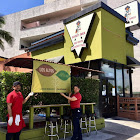
Los Altos Great Mex displays neighborhood flag

Lloyd Whaley developed the planned community neighborhoods of  East Long Beach including Los Altos Village and Park Estates (originally called Los Altos Park Estates). Whaley also planned and built the Los Altos Shopping Center .


Other Whaley developments include the neighborhood of Country Club Manor in North Long Beach and the Galaxy Tower on Ocean Blvd in Bluff Park.  Whaley donated land for numerous public uses around Long Beach including Whaley Park, the Los Altos Public Library, Los Altos Park and Scherer Park.

The Lighting of the Letters event will begin at 3:00 pm at Whaley Park (North) on Sunday December 3rd and continue until the letters light-up at dusk.

To contribute to the Los Altos Giving Fund click on: LOS ALTOS 


Kumon Math & Reading Center opens in 
Los Altos Center North
A  Kumon Math & Reading Center has opened up at the Los Altos Center North  in the upstairs of the Trader Joes/Amazing Comics section building in Suite 208.

Los Altos Center Kumon Center Grand Opening ribbon cutting from Councilman Supernaw's weekly newsletter 

Kumon's is an after-school academic enrichment program.  The Kumon program to motivate students and instill a love of learning.  The advance at your own pace program is individualized for students who either in need of catching up or enrichment. 

For more information click on: KUMON@Los Altos Village


Bellflower Blvd's 2.1 million dollar mile
Starting Monday November 27th, construction on the Bellflower Blvd's $2.1 million mile is set to begin.  The City of Long Beach in conjunction with 3rd District Councilwomen Suzie Prices' office will be  repaving and reconfiguring Bellflower from PCH to Atherton Street including the area known as the Iron Triangle- the PCH/7th Street/Bellflower Blvd. intersection.  The 3rd District project will stop at the 4th District line which is the Boulton Creek flood channel right before the YMCA.

3rd District Councilwomen Price
Prices' office announced the project in Spring of this year. The project had been delayed because of street construction inside of CSULB that caused CSULB students to enter the campus by way of Atherton Street.  The delayed construction will now impact Third District residents traveling to the Los Altos Village shopping centers and restaurants for the holidays and 4th District residents traveling south to the Marina Pacifica Shopping areas during the shopping season.
  
The bulk of the $2.1 million funding for the 1.1 mile stretch is being paid for by federal and state monies with Long Beach funding $211,000 of the project. 

At least one lane of Bellflower Blvd. and reportedly 25 parking spaces on Bellflower will be eliminated as bike lanes protected by "bike bollards" will be added to the street. Those green bollards have been controversial not only in Long Beach but in Los Angeles.


For more information click on BIKE BOLLARDS

Tuesday, November 21, 2017

City's Misleading Holiday Messages

The Nightmare Before Christmas from Long Beach city management..


City Management's holiday message to LB neighborhoods 
City management  
eblasts a misleading Holiday Summary of new Land Use Element changes

On Monday November 20, during the traditional kick-off to the holidays, the City of Long Beach management started a series of misleading Holiday Summary email blasts about the controversial  Land Use Element (LUE) Placetype maps that spreads downtown density across Long Beach.


The email blasts come after the near universal outcry over the "new" LUE maps that were released this month.  LB Development Services Director Amy Bodek's department and City Manager Pat West had touted for weeks that the city "heard" the overwhelming response from the residents that attended the four recent Community meetings.

While the city-wide misrepresentations are too numerous to address from across the city during the holidays, here are  just a few examples from the city's Holiday Summary about the Fourth District areas on the new LUE maps sent out today and the Real Facts.

Traffic Circle
Here is the part of the city management's Holiday Summary that deals with the Traffic Circle:
"Reduced height around the eastern portion of the traffic circle from 6 stories to 4 stories"

The Real Facts
The Traffic Circle is the most traffic accident prone area of the city.  Here is what that ONE line from the  Holiday Summary DOES NOT report about the "new maps":
·       What the "Reduced Height" means is now instead of tripling the height density of the areas East of Clark and North of PCH the new maps are just DOUBLING the height density.
·       The Von's property portion of the Circle Center still will allow mixed-use high density apartments. Since it is currently zoned commercial- the land qualifies under the new state law SB 35 for Super Sizing Density . That state law includes: ADDED height and density beyond what the city zoning allows; NO PARKING requirements; and other added high density big developer perks when defined affordable housing is included in the high density development
·       The new maps include DOUBLING the current heights and density of the apartments East of the Vons Center and Northeast of the center along Los Coyotes Diagonal.
·       The new maps do not change the Western Part of the Traffic Circle.  That area remains six stories mixed-use high density apartments.  PLUS, all of the land in these  commercial areas  qualify for Super Sizing Density under the new state law SB 35: ADDED height and density beyond what the city zoning allows; NO PARKING requirements; and other added high density big developer perks when defined affordable housing is included in the high density development:
1.    the Circle Center Ralphs property
2.    the Staples/Big Five/Circle Wash property
3.    the Free Conference Call, UFC Gym property
4.    the Circle Porsche property
5.    the Circle Audi property
6.    the Community Hospital property
7.    the oil tank property
·       The new maps include high density housing for the business properties currently at the second worst intersection in the 4th District- the Lakewood Blvd/Stearns/Clark intersection. These  commercial areas  qualify for Super Sizing Density under the new state law SB 35: ADDED height and density beyond what the city zoning allows; NO PARKING requirements; and other added high density big developer perks when defined affordable housing is included in the high density development:
1.     El Pollo Loco/Medical Building property
2.    Hertzog Eye Doctor property
  • The Traffic Circle and PCH are under the control of the State of California. The city cannot make any changes to improve traffic flow due to adjacent high density residential development.
The Los Altos Sears Center
Here is the part of the city management's Holiday Summary that deals with the Los Altos Sears Center:
"Reduced height and intensity at Bellflower/Stearns from 5 stories to 3 stories (Sears site)"

The Real Facts
The Los Altos Center is part of the original plans of the Los Altos Village planned community- one of the nation's first post World War II planned single family neighborhoods.  Here is what that ONE line from the  Holiday Summary DOES NOT report about the "new maps":
·       The Holiday Summary does not state that the Sears property is being changed from Commercial Development to Mixed-Use Development (all purple and light purple areas) a change that allows high density apartments right in the middle of the Los Altos single family neighborhood zones
·       As a currently Commercial Zone the Sears Center property qualifies for Super Sizing Density under the new state law SB 35: ADDED height and density beyond what the city zoning allows; NO PARKING requirements; and other added high density big developer perks when defined affordable housing is included in the high density development making the 3 story Placetype limit moot.
·       Multi-use development has the potential of adding hundreds of residents in high density apartments directly under the flight path of landing jets

The Anaheim, Redondo, Ximeno, 10th Street Corridors
Here are parts of the city manager's Holiday Summary that deals with the Anaheim Corridor:
"Reduced height along Anaheim - from 5 stories to 4 stories"

"Reduced height along Redondo south of Anaheim; from 5 stories to 4 stories"

"Reduced height along Anaheim - from 5 stories to 4 stories from Redondo to Ximeno; and to 3 stories from Ximeno to Clark"

The Real Facts
Much of these transit corridors are made up of commercial properties that literally surround neighborhoods that were forever changed by the Crackerbox Planning that allowed low-parking-requirement dense apartment complexes the last time the City of Long Beach looked at spreading density in the 1980's.  Here is what the Holiday Summary DOES NOT report about the "new maps":
·       The "new maps" change the current residential and commercial zoning along  those major corridors to mixed use high density- allowing high density apartments ( all purple and light purple areas)
·       All the currently zoned commercial areas along the corridors (ie LB Playhouse property, nursing homes, car facilities) would qualify for Super Sizing Density under the new state law SB 35: ADDED height and density beyond what the city zoning allows; NO PARKING requirements; and other added high density big developer perks when defined affordable housing is included in the high density development

SEND YOUR OWN HOLIDAY MESSAGE TO THE CITY

Please go here to sign the petition currently circulating:

Friday, November 10, 2017

City to ELB: SCREW YOU

City says Screw You to ELB residents...
complete with a boldface lie:

"With no changes to many traditional shopping centers"

New Land Use Element (LUE) maps:
·      Los Altos Center- Mixed-use High Density Apartments
·      Los Altos Gateway- Mixed-use High Density Apartments
·      Circle Center: Mixed Use High Density Apartments
·      PCH/Triangle: Mixed Use High Density
·      Anaheim Street: Mixed Use High Density
·      Los Coyotes Diagonal-High Density Apartments
·      Recreation Park/Wilson High School Adjacent: Mixed Use High Density Apartments
·      Redondo Ave Zaferia District Adjacent: Mixed Use High Density Apartments
·      Cherry Ave: Mixed Use High Density Apartments

“It is clear from the community input we have received that changes to the proposed maps were necessary”
-City Manager Patrick H. West in LUE press release 11/10/17

After four community meetings with hundreds of residents showing-up protesting the mixed-use high density Land Use Element in East Long Beach, the Development Services released the new "revised" high density maps.   

While the original maps before the August 17, 2017 Planning Commission had NO increased density in the single family neighborhoods of East Long Beach, the New LUE maps continue to spread high density "mixed-use" (taking current commercial property and allowing residential) across East Long Beach.

Unbelievably,  the November 10th press-release statement that announced the new LUE maps that allows high density apartments at the Los Altos Center, the Circle Center and the Los Altos Gateway Center states:  
"With no changes to many traditional shopping centers"


The new LUE plan is particularly ominous because of  the passage of SB 35 which would allow super-sizing with NO PARKING requirements at current commercial centers. High Density apartments with qualifying "affordable" units at the Los Altos Center (Sears) and the Los Altos Gateway (Lowes/Kmart) would potentially qualify for NO PARKING requirements.

Most disturbing is that Long Beach Development Services Director Amy Bodek personally ran the October 4th Whaley Park Community Meeting and saw the close to 1000 people show up to the meeting against high density mixed use apartments in East Long Beach.

West 4th District's Crackerbox Land gets 
more density !

Amy Bodek's department also zeroed in on the over-crowded western portion of the 4th District that is home to hundred's of the disastrous 1980 "crackerbox style" apartments. 


Bodek's solution? MORE DENSITY!

Under the new LUE, the residents of the  Zaferia District and the AOC7 Neighborhoods  would be boxed in by density on the neighborhoods main arteries:  Anaheim, Redondo, Cherry, 10th and 7th streets.

The next step is for the Planning Commission to take up the LUE again.  The most likely date for the Planning Commission is December 7th. After being "approved" by the Planning Commission, the next step will be the City Council.

To see the "new revised" LUE maps click on: 
SCREW YOU MAPS


Councilman Supernaw wastes no time in saying NO to the new LUE maps
Fourth District Councilman Daryl Supernaw wasted no time in sending our a statement saying he does not support the new LUE Maps.
 
Less than an hour after the maps were released to the public, Supernaw released this statement in his weekly newsletter:

"The City released the revised Land Use Element Maps today. While most of the height increases were removed east of Clark Ave., much of the density remains on the western side of our district. The Los Altos Shopping Center, southeast of Bellflower and Stearns, remains mixed use commercial/residential. The proposed heights, while reduced from the August map, still include increased density on the north/south corridors of Clark, Los Coyotes Diagonal, Redondo and Cherry. Also, the east/west corridors of 10th St., Anaheim and PCH include increased height. For this reason, I will, not be able to support the proposed Land Use Element map for CD4."    
-4th District Councilman Daryl Supernaw 11/10/17